

Global Earth Observation Data Services Market Size and Forecast – 2026 To 2033
The global earth observation data services market is expected to grow from USD 4.95 Bn in 2026 to USD 8.55 Bn by 2033, registering a compound annual growth rate (CAGR) of 8.2% from 2026 to 2033. The global earth observation data services market is driven by growing use of Earth observation data for disaster monitoring. On March 31, 2025, ICEYE, the global leader in satellite-powered disaster management solutions, launched its industry-first hurricane data solution for weather events impacting the US. The Hurricane Solution provides insurers with impact information from both wind and flooding within 24 hours of a hurricane making landfall.
Key Takeaways of the Global Earth Observation Data Services Market
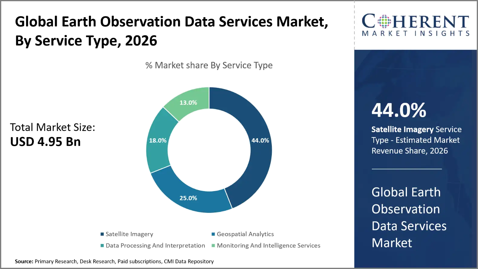
- The Satellite Imagery segment is expected to account for 44.0% of the global earth observation data services market share in 2026. Increasing government investments in environmental monitoring programs is driving the growth of the segment. On July 3, 2025, Kuva Space partnered with the Finnish Environment Institute to improve inland and coastal water monitoring.
- The Optical Imagery segment is estimated to capture 38.0% of the market share in 2026. Rising demand for satellite-based climate intelligence is majorly driving the growth of the segment. On September 23, 2025, Planet Labs announced general availability of its Tanager-1 hyperspectral satellite data products. The offering includes radiance and surface reflectance imagery.
- The Agriculture And Forestry segment is estimated to capture 32.0% of the market share in 2026. Expansion of commercial high-resolution satellite imaging services is driving the growth of the segment. On February 25, 2025, NTT DATA and Marble Visions initiated development of a high-resolution, high-frequency satellite observation system. The project involves PASCO Corporation and Canon Electronics.
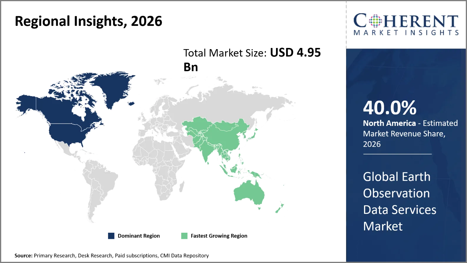
- North America is expected to dominate the earth observation data services market in 2026 with a market share of 40.0%. Growing demand for real-time disaster monitoring solutions in North America is driving the growth of the regional market. On August 11, 2025, Verizon partnered with Hyfi and the Center for Neighborhood Technology to deploy 50 floodwater sensors across Chicago, Illinois. These sensors operate on Verizon’s 5G network and monitor flood-prone neighborhoods.
- Asia Pacific is expected to account for 29.0% share in 2026. Increasing adoption of geospatial intelligence in infrastructure planning in Asia Pacific is driving the growth of the regional market. On January 27, 2026, Eartheye Space Technologies signed a memorandum with Sarawak Information Systems. The partnership targets satellite imagery processing using radar, optical, and hyperspectral data.
Segmental Insights
Why Does Satellite Imagery Dominate the Global Earth Observation Data Services Market?
The satellite imagery segment is expected to account for 44.0% of the global earth observation data services market share in 2026. The satellite imagery segment is the most dominant, owing to the wide geographical coverage and continuous monitoring capabilities. Satellite observations are becoming increasingly important for government agencies, defense organizations and commercial firms. These data sets are used for environmental monitoring, infrastructure planning, disaster management and national security operations. Increasing satellite constellations increase the revisit frequencies and geographical resolution. Advances in artificial intelligence will speed up picture processing and make possible automatic feature recognition. Commercial access to satellite imagery also enables applications across many industries. These advantages strengthen satellite imagery adoption among public and private sector users.
O May 26, 2026, Satellogic Inc., a vertically integrated geospatial company delivering high-resolution Earth Observation (EO) at unprecedented scale and economics, announced it has secured a one-year contract valued at more than USD 18 million with an international defense customer for persistent, high-frequency Earth observation imagery.
- Current Industry Events of 2026
- Market Size Estimation
- Regional Breakdown
- Competitive Landscape
- Customer Intelligence
- Segmental Analysis
- Pricing Analysis
- Key Market Drivers, Challenges & Future Trends
- Customized Insights Section
Why is Optical Imagery the Most Preferred Data Type?
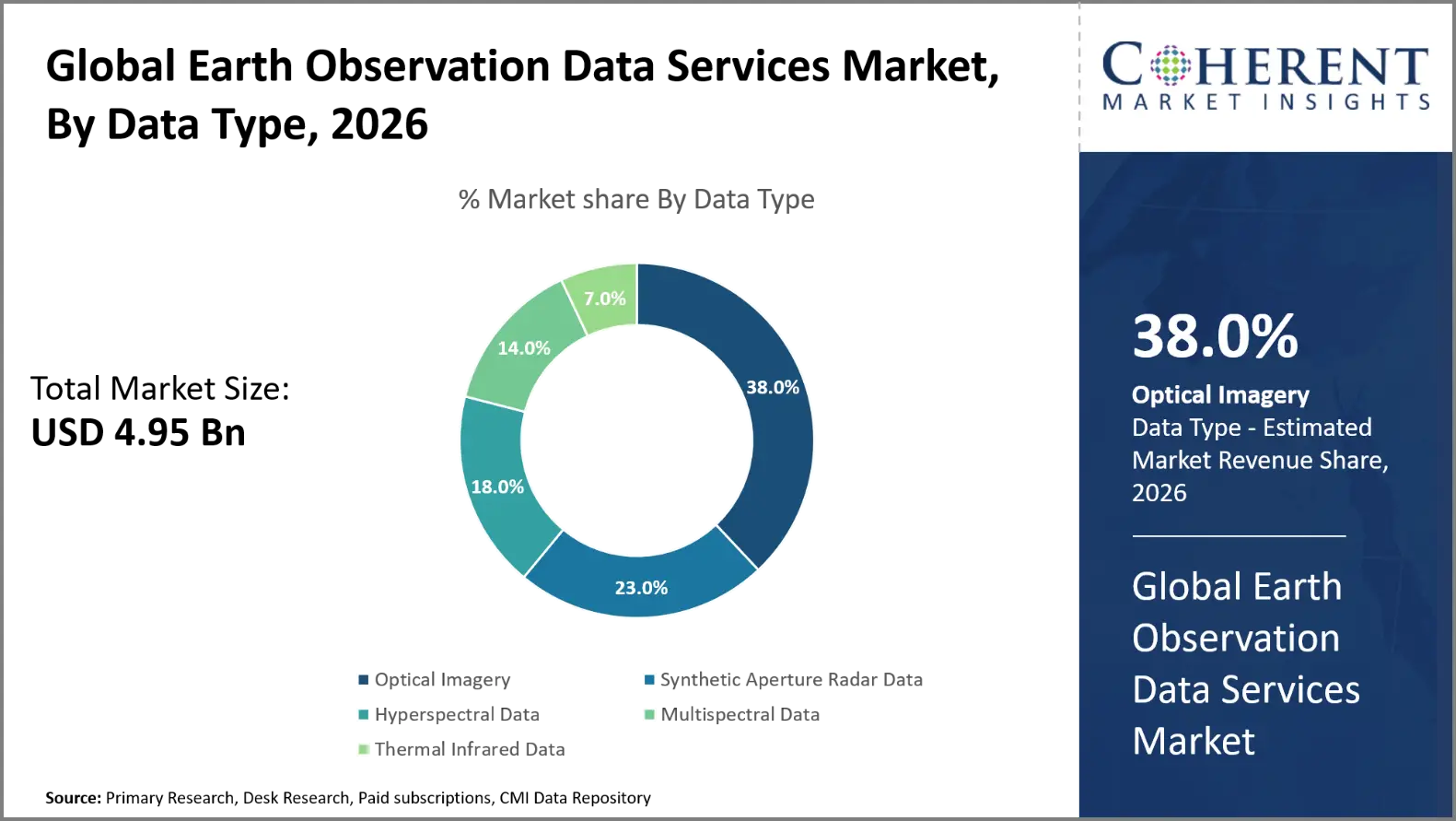
The optical imagery segment is expected to account for 38.0% of the global earth observation data services market share in 2026. Optical imaging is still the most desired kind of data as it gives recognizable visual information about the earth’s surface. High-resolution optical sensors are employed to obtain data on land cover, vegetation status, urban sprawl, and infrastructural changes. These photos are used to support agricultural assessments, forest management, construction monitoring and environmental investigations. Multispectral imaging enhancements are helping users to identify vegetation health and surface properties. Commercial companies are increasingly providing frequently updated images to support operational decision making. Optical datasets are also easily integrated into artificial intelligence platforms and geographic information systems.
On March 4, 2026, EarthDaily released processed images from its first EarthDaily Constellation satellite, EDC-01. ABB developed the satellite's multispectral imaging payload, which began delivering imagery during 2025. The spacecraft carries 16 multispectral imagers providing broad spectral coverage.
Agriculture And Forestry Dominates the Global Earth Observation Data Services Market
The agriculture and forestry segment is expected to account for 32.0% of the global earth observation data services market share in 2026. Agriculture and forestry dominate application demand because both sectors require continuous monitoring of extensive land areas. Satellite observations are used by farmers to analyze crop health, water stress, and vegetation growth. Multispectral photography is useful in detecting nutrient shortages and developing crop disease. Forestry groups track the consequences of deforestation, forest degradation, biomass distribution and wildfires. Government agencies also employ Earth observation databases to monitor land-use changes and facilitate environmental compliance. Climate unpredictability enhances the need for reliable agricultural assessment and forest monitoring. Increasing adoption of precision agriculture further boosts the demand for satellite-based data services.
On March 3, 2026, ICEYE announced the debut of its dedicated deforestation monitoring tool. The service uses synthetic aperture radar satellites to detect forest disturbances despite persistent cloud cover. It provides near-real-time information about illegal logging and forest clearing.
Current Events and their Impact
Current Events | Description and its Impact |
U.S. - Land Remote Sensing Policy Act of 1992 and 15 CFR Part 960 |
|
European Union - Copernicus Program Regulation (EU) 2021/696 |
|
Earth Observation Data Services Market Dynamics
Market Drivers
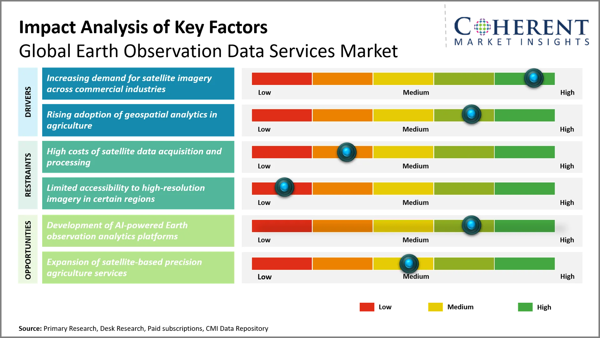
Increasing demand for satellite imagery across commercial industries
The commercial sectors are increasingly demanding satellite images for operational monitoring and strategic decision-making. Construction companies employ high-resolution photos to monitor project status, land development and infrastructure status. Utilities look at where their pipelines, mines, and renewable energy projects are. Insurers utilize satellite views to assess property vulnerability and estimate losses from disasters. Telecom businesses look at terrain features and chances to grow infrastructure. Retail and logistics firms are using satellite imagery to gain more knowledge about urban development and transit networks. The more often the images is refreshed, the stronger the commercial uptake. These applications heighten the need for strong Earth Observation data offerings across industry sectors.
On May 28, 2026, GISPartner and ICEYE signed a partnership agreement on commercial infrastructure intelligence in Poland. The agreement combines ICEYE’s synthetic aperture radar imaging with GISPartner’s iMapCLOUD technology.
Rising adoption of geospatial analytics in agriculture
Geospatial analytics is being increasingly used by agriculture companies to improve crop management and resource efficiency. Farmers can use satellite data to monitor crop health, soil moisture and crop development over large areas of field. Multispectral observations can help to identify nutrient deficiency, irrigation requirements and potential disease outbreaks. Geographic information systems integrate satellite observations, meteorological information and ground-level measures. Companies such as John Deere are embedding geospatial intelligence into precision agriculture applications. Planet Labs offers updated imagery regularly to enhance agriculture monitoring. Such capabilities can assist farmers optimize input consumption, improve field management and reduce operational uncertainty. The increasing variability of the climate is increasing the demand for satellite-based agricultural analytics.
On August 5, 2025, SatSure Analytics India Pvt. Ltd., a leading Earth Observation (EO) data refinery platform, collaborated with Kenya Agricultural and Livestock Research Organization (KALRO) to change agricultural productivity and resilience in Kenya using modern satellite data and analytics.
Emerging Trends
- Integration of Artificial Intelligence with Satellite Imagery Analysis: More and more companies that deal with earth observation are turning to artificial intelligence to analyze satellite imagery. Automated classification, object detection and change detection enhance analytical velocity. These capabilities allow for more rapid environmental assessments and speedier commercial intelligence gathering.
- Impact: Artificial Intelligence eliminates manual interpretation of images and speeds up extraction of information. It enhances the precision of monitoring, the efficiency of operations and the ability to process huge amounts of data. This provides more rapid transmission of actionable geospatial intelligence.
- Relevance to the market: Planet Labs is incorporating artificial intelligence into its Planetary Variables products. These features facilitate agricultural monitoring, forest assessments and infrastructure change detection that increases the demand for analytics enabled images subscriptions.
- Expansion of High-Frequency Satellite Imaging Constellations: Commercial satellite operators are expanding imaging constellations to boost revisit frequency. Better coverage allows more frequent observation of agricultural fields, infrastructure projects, environmental changes and disaster impacted sites.
- Impact: Increased visitation rate increases the temporal monitoring and lowers the lags in detecting the surface changes. Businesses can receive updated information to help plan their operations and to adjust more rapidly to changing situations.
- Relevance to the market: BlackSky has high-frequency monitoring capabilities for time-sensitive intelligence needs. Its Spectra platform is a response to demand for regularly refreshed geospatial information among defense and commercial customers.
Regional Insights
Why is North America a Strong Market for Earth Observation Data Services?
North America is expected to account for a market share of 40.0% in 2026. North America is supported by robust commercial satellite acquisition, defense intelligence requirements, and mature geospatial technology infrastructure. The region’s demand is increasingly shaped by the operational integration of satellite observations and government decision-making. In June 2026, the National Aeronautics and Space Administration picked eight more commercial satellite data providers. The contract unlocked access to thermal infrared, hyperspectral, greenhouse gas and radar observations. Meanwhile, the National Oceanic and Atmospheric Administration expanded commercial environmental data procurement. Its new program supports atmospheric profiling and space weather monitoring. These developments strengthen demand for specialized satellite datasets and recurring analytical services across North American industries
Why Does Asia Pacific Earth Observation Data Services Market Exhibit High Growth?
Asia Pacific is expected to register the fastest growth with a CAGR of 8.8% over the forecast period. Asia Pacific is projected to account for 29.0% of the global earth observation data services market in 2026. Asia Pacific benefits from increasing satellite data integration into municipal administration, coastal monitoring, and regional disaster management. The Japan Aerospace Exploration Agency encourages the use of satellites for maritime surveillance, infrastructure monitoring and agricultural evaluation. The Advanced Land Observing Satellite-2 is equipped with radar to detect urban ground subsidence. South Korea started its AI-based satellite use program in June 2026. Demonstration projects cover geological hazard identification in Jeju and marine debris monitoring in Jeollanam-do. South Korea also plans 13 industrial service models across participating municipalities. These developments encourage subscription-based geospatial analytics and locally tailored satellite information services.
Global Earth Observation Data Services Market Outlook for Key Countries
Why is U.S. Emerging as a Major Hub in the Earth Observation Data Services Market?
The U.S. market gains from increased commercial intelligence acquisition by defense and national security groups. The Space Force's Joint Commercial Operations Cell spent USD 76.8 million through the Global Data Marketplace, according to the Government Accountability Office. This spending included commercial space data and services from January 2023 to September 2025. The National Reconnaissance Office and National Geospatial-Intelligence Agency also bought commercial imagery and analytical tools. These procurement procedures drive need for persistent surveillance, marine intelligence and infrastructure monitoring. The military’s increasing reliance on external data providers presents potential for specialist imaging suppliers and geospatial intelligence platforms.
Is China the Next Growth Engine for the Earth Observation Data Services Market?
China’s market benefits from expanded capabilities for hyperspectral observation and substantial satellite-based environmental monitoring programs. Gaofen-5 01A hyperspectral satellite was commissioned by the China National Space Administration (CNSA) in January 2024. Its devices are used to monitor air pollution, mineral prospecting, water quality and to identify methane emissions. The satellite enables daily atmospheric environmental observations and land surface monitoring every two days. A 2026 research publication identified 33 operational Chinese Earth observation satellites as of May 2026. Their optical, infrared and radar tools assist geological investigation, agricultural surveys and natural resource management. These capabilities strengthen domestic demand for specialized remote sensing products.
Germany Earth Observation Data Services Market Analysis and Trends
Germany benefits from established commercial distribution of three-dimensional terrain information and advanced radar-derived elevation products. The German Aerospace Center’s TanDEM-X mission has been in operation for 15 years. It gives a worldwide elevation model to facilitate glacier measurements, woodland mapping, urban footprint identification and agricultural research. So far, more than 6,500 researchers have used TanDEM-X datasets for scientific purposes. So, there is a commercial distribution channel in place. These products are commercially marketed by Airbus Defense and Space. Germany also runs the Copernicus Data and Exploitation Platform which supports access and processing of satellite data. Those capabilities create demand for elevation intelligence and specific geospatial data sets.
France Earth Observation Data Services Market Analysis and Trends
France has long-established commercial satellite imagery, institutional data purchase, and specialist environmental intelligence operations. The National Center for Space Studies established the GEODES site in 2024, a single access point for Sentinel, SPOT and Pléiades information. It produces very-high-resolution commercial imagery, including 50-centimetre observations, through its DINAMIS platform. September 2026: provision by DINAMIS of 18 satellite scenes over the Pays Basque area for territorial planning. France 2030 supports seven demonstration subjects, including hydrology, coastal monitoring, wildfire control and maritime surveillance. These activities drive demand for specialist geospatial processing and earth observation services for government.
India Earth Observation Data Services Market Analysis and Trends
India’s market is developing through public-private partnerships for indigenous Earth observation satellite constellations. In August 2026, the Indian government announced a framework that allowed private firms to design, build and operate satellites. The planned constellation would consist of five ultrahigh resolution optical satellites and two X-band synthetic aperture radar satellites. It also includes three multispectral satellites and two hyperspectral satellites. Applications from Indian Space Research Organization are already aiding in crop estimation in several agricultural areas. These activities open up potential for domestic imagery processing, satellite data distribution and specialist geospatial intelligence providers.
Global Earth Observation Data Services Market - Earth Observation Satellite Constellation Capacity (As of 2026)
Country | Operator | Satellite Constellation | Sensor Type | Operational Satellite Count |
U.S. | Capella Space | Capella | X-band SAR | 11 |
U.S. | NASA / U.S. Geological Survey | Landsat 8 and Landsat 9 | Optical multispectral and thermal | 2 |
China | Chang Guang Satellite Technology | Jilin-1 | Optical, multispectral and infrared | 34 |
Argentina | Satellogic | NewSat | Optical multispectral | 17 |
UAE | Space42 | Foresight | X-band SAR | 5 |
How is Development of AI-Powered Earth Observation Analytics Platforms Creating New Growth Opportunities in the Earth Observation Data Services Market?
The development of AI-powered Earth observation analytics platforms creates growth opportunities by converting raw satellite imagery into decision-ready intelligence. Google DeepMind’s AlphaEarth Foundations merges optical images, radar and laser mapping into a consistent geographic representation with 10-meter grid units. Space42 is working with Microsoft to build its Geospatial Intelligence Quotient platform, which integrates imagery purchase, model deployment, and automated reporting. Pixxel’s Aurora platform allows customers to mix hyperspectral imagery, analytical models, and unique workflows without having to write much code. India’s SatSure obtained a USD 2.6 million government grant in June 2026 to create indigenous Earth observation foundation models. These innovations present economic prospects in automated geospatial intelligence, customized analytics subscriptions, and customized enterprise data services.
On October 25, 2026, Hanwha Systems launched its newly created next-generation satellite imagery analysis technology for the first time in an international market. The Space AI Analytics Solution employs AI to accurately read and analyze image data sent from satellites to ground stations, then summaries the important information and delivers it.
Market Players, Key Development, and Competitive Landscape
Key Developments
- On October 30, 2026, Capella Space successfully launched two new Acadia-class satellites, C-21 (Acadia-11) and C-22 (Acadia-12), aboard SpaceX's Falcon 9 rocket as part of the Bandwagon-5 rideshare mission from Cape Canaveral Space Force Station in Florida.
- On September 16, 2026, MDA Space Ltd, a trusted mission partner to the global defense and space industry, unveiled the end-to-end MDA CHORUS Earth observation (EO) product portfolio. The introduction of the full portfolio precedes the highly anticipated launch of the MDA CHORUS constellation later this year.
- On August 11, 2025, Umbra, a leading American space technology company, announced the official launch of its new Space Systems business unit at the Small Satellite Conference in Salt Lake City, Utah. This strategic expansion brings Umbra’s flight‑proven, American‑made hardware directly to the global market for the first time.
Competitive Landscape
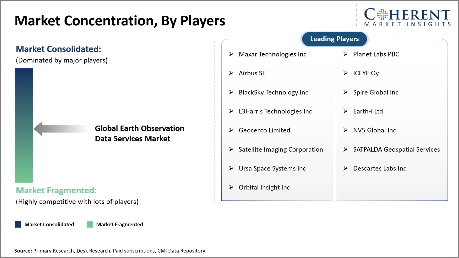
The competitive landscape features established satellite imagery providers and specialized companies offering radar, optical, and geospatial intelligence services. Planet Labs focuses on frequent global imaging, analysis-ready datasets, and cloud-based delivery. Maxar Intelligence emphasizes very-high-resolution imagery, three-dimensional mapping, and government intelligence contracts. Airbus Defense and Space bolsters position with Pléiades Neo imagery and OneAtlas distribution services. ICEYE has experience in synthetic aperture radar imaging for flood monitoring, defense and insurance applications. BlackSky’s point of differentiation is quick imagery collecting and automated intelligence dissemination. Strategic alliances, satellite constellation expansion, proprietary analytics and government procurement continue to be key competitive strategies. But the European Space Agency’s Digital EO contract, given to OVHcloud and CGI (September 2026), is a sign of the expanding rivalry around data infrastructure.
Top Manufacturers and Notable Products in the Earth Observation Data Services Market
Manufacturer | Notable Product | Key features |
Planet Labs PBC | PlanetScope and SkySat | Near-daily global coverage, 3 m PlanetScope imagery, 50 cm SkySat imagery, frequent revisit, historical imagery archive, AI-based change detection |
Vantor (formerly Maxar Intelligence) | WorldView Legion | 30 cm-class very-high-resolution imagery, detailed urban observation, multispectral data, high-resolution satellite tasking, extensive imagery archive |
Airbus Defence and Space | Pléiades Neo | 30 cm native resolution, daily revisit capability, rapid tasking, 3.5 m CE90 location accuracy, stereo and tri-stereo acquisition |
ICEYE | ICEYE SAR and Dwell Precise | Up to 25 cm resolution, day-and-night imaging, all-weather observation, multiple imaging modes, sub-daily monitoring |
BlackSky Technology Inc. | BlackSky Spectra and Gen-3 | 35 cm native resolution, AI-powered object detection, rapid satellite tasking, activity monitoring, automated imagery analysis |
Market Report Scope
Report Coverage | Details | ||
Base Year | 2025 | Market Size in 2026: | USD 4.95 Bn |
Historical Data For: | 2020 To 2024 | Forecast Period: | 2026 To 2033 |
Forecast Period 2026 To 2033 CAGR: | 8.2% | 2033 Value Projection: | USD 8.55 Bn |
Geographies covered: |
| ||
Segments covered: |
| ||
Companies covered: | Maxar Technologies Inc, Planet Labs PBC, Airbus SE, ICEYE Oy, BlackSky Technology Inc, Spire Global Inc, L3Harris Technologies Inc, Earth-i Ltd, Geocento Limited, NV5 Global Inc, Satellite Imaging Corporation, SATPALDA Geospatial Services, Ursa Space Systems Inc, Descartes Labs Inc, Orbital Insight Inc | ||
Growth Drivers: |
| ||
Restraints & Challenges: |
| ||
Analyst Opinion (Expert Opinion)
- The industry will increasingly shift from standalone satellite imagery licensing toward continuous geospatial intelligence services. Customers will prioritize automated alerts, historical comparisons, and customized monitoring rather than purchasing isolated images. Synthetic aperture radar and hyperspectral datasets will gain importance because they address monitoring requirements beyond conventional optical imaging. Cloud-based processing and interoperable data platforms will become essential commercial capabilities. Providers combining proprietary imagery with specialized analytical software will have stronger opportunities to establish recurring customer relationships.
- The strongest opportunities will emerge in synthetic aperture radar, hyperspectral imagery, and high-resolution optical data services. Defense intelligence, precise mining, marine surveillance and risk assessment of infrastructure are promising applications. There is scope for specialist commercial services in India, Japan, Germany and the U.S. India has possibilities in agricultural insurance and mineral prospecting. Japan has prospects in earthquake monitoring and coastal infrastructure assessment. Germany has prospects in industrial asset monitoring and environmental compliance. Companies should focus on applications where frequent observations and special interpretation are needed.
- Market participants should develop proprietary analytical models rather than depending entirely on third-party imagery distribution. Partnerships with agricultural insurers, energy operators, mining companies, and infrastructure developers can secure recurring contracts. Companies should establish sensor-specific processing capabilities for radar, hyperspectral, and thermal datasets. Flexible subscription models can attract customers with different monitoring requirements. Providers should also develop application programming interfaces for integration with enterprise software. Strong data security, reliable delivery timelines, and customized intelligence products will help companies differentiate their services.
Speak to the analyst
Want personalized insights?
Take the findings above to one of our principal consultants, or have the report rebuilt around the segments, geographies and competitors you actually track.
Market Segmentation
- Service Type Insights (Revenue, USD Billion, 2021 - 2033)
- Satellite Imagery
- Geospatial Analytics
- Data Processing And Interpretation
- Monitoring And Intelligence Services
- Data Type Insights (Revenue, USD Billion, 2021 - 2033)
- Optical Imagery
- Synthetic Aperture Radar Data
- Hyperspectral Data
- Multispectral Data
- Thermal Infrared Data
- Application Insights (Revenue, USD Billion, 2021 - 2033)
- Agriculture And Forestry
- Environmental Monitoring
- Defense And Intelligence
- Disaster Management
- Infrastructure And Urban Planning
- Energy And Natural Resources
- Maritime Monitoring
- Weather Forecasting
- Others
- End User Insights (Revenue, USD Billion, 2021 - 2033)
- Government And Military
- Commercial Enterprises
- Agriculture And Forestry Organizations
- Energy And Utility Companies
- Infrastructure And Construction Companies
- Research And Academic Institutions
- Insurance Companies
- Regional Insights (Revenue, USD Billion, 2021 - 2033)
- North America
- U.S.
- Canada
- Latin America
- Brazil
- Argentina
- Mexico
- Rest of Latin America
- Europe
- Germany
- U.K.
- Spain
- France
- Italy
- Russia
- Rest of Europe
- Asia Pacific
- China
- India
- Japan
- Australia
- South Korea
- ASEAN
- Rest of Asia Pacific
- Middle East
- GCC Countries
- Israel
- Rest of Middle East
- Africa
- South Africa
- North Africa
- Central Africa
- North America
- Key Players Insights
- Maxar Technologies Inc
- Planet Labs PBC
- Airbus SE
- ICEYE Oy
- BlackSky Technology Inc
- Spire Global Inc
- L3Harris Technologies Inc
- Earth-i Ltd
- Geocento Limited
- NV5 Global Inc
- Satellite Imaging Corporation
- SATPALDA Geospatial Services
- Ursa Space Systems Inc
- Descartes Labs Inc
- Orbital Insight Inc
Sources
Primary Research Interviews
- Satellite Data Providers & Operators
- Geospatial Analytics Solution Providers
- Government & Defense Agency Representatives
- Remote Sensing Technology Developers
Magazines
- GeoSpatial World Magazine
- Satellite Evolution Global
- Earth Imaging Journal
- GPS World Magazine
Journals
- Remote Sensing of Environment (Elsevier)
- IEEE Transactions on Geoscience and Remote Sensing
- International Journal of Applied Earth Observation and Geoinformation
Associations
- Group on Earth Observations (GEO)
- Satellite Industry Association (SIA)
- American Society for Photogrammetry and Remote Sensing (ASPRS)
- European Association of Remote Sensing Companies (EARSC)
Public Domain Sources
- NASA Earthdata Open Access Portal (earthdata.nasa.gov)
- European Space Agency (ESA) Open Data Hub (esa.int)
- United Nations Office for Outer Space Affairs (UNOOSA) Reports
- World Bank Open Data – Geospatial Datasets
Proprietary Elements
- CMI Data Analytics Tool
- Proprietary CMI Existing Repository of Information for Last 10 Years
Get access to 250+ pages report
Every segment, forecast, competitor profile and data table behind the analysis above — available for instant download.
- ESOMAR Member
- ISO 9001:2015 Certified
- D-U-N-S Registered
- GDPR & CCPA Compliant
Frequently Asked Questions
The global earth observation data services market is expected to stand at USD 4.95 Bn in 2026 and is expected to reach USD 8.55 Bn by 2033.
The CAGR of the global earth observation data services market is projected to be 8.2% from 2026 to 2033.
Increasing demand for satellite imagery across commercial industries and Rising adoption of geospatial analytics in agriculture are the major factors driving the growth of the global earth observation data services market.
High costs of satellite data acquisition and processing and Limited accessibility to high-resolution imagery in certain regions are the major factors hampering the growth of the global earth observation data services market.
In terms of service type, satellite imagery segment is estimated to dominate the market revenue share in 2026.
Earth observation supports forest inventory mapping, deforestation identification, wildfire assessment, biomass estimation, and vegetation change monitoring.
Earth observation data services provide satellite-derived information, imagery, and analytical products for monitoring Earth's surface, atmosphere, oceans, and environmental conditions.