

Global Hydrographic Surveys Market Size and Forecast – 2026 To 2033
The Global Hydrographic Surveys Market is estimated to be valued at USD 4.32 Bn in 2026 and is expected to reach USD 6.76 Bn by 2033, growing at a compound annual growth rate (CAGR) of 6.6% from 2026 to 2033. The market growth is supported by increasing requirements for accurate seabed mapping, maritime infrastructure planning, offshore energy development, coastal management, and underwater asset monitoring. The transition toward high-resolution survey technologies, including multibeam sonar, autonomous platforms, and digitally integrated marine data solutions, is improving survey efficiency and expanding applications beyond traditional navigation needs.
Government hydrographic agencies, offshore operators, and port authorities are increasingly investing in updated marine datasets to support safer navigation, infrastructure development, and resource assessment. In February 2025, NOAA initiated its 2025 hydrographic survey season, deploying survey vessels and contractors to collect bathymetric data for nautical charting, marine research, and ecosystem management, highlighting continued institutional demand for advanced hydrographic capabilities.
Key Takeaways of the Global Hydrographic Surveys Market
- General Hydrographic Surveys are projected to expand at a CAGR of 6.5%, capturing 31.8% share of the global hydrographic surveys market in 2026 as they remain the primary service category for navigation charting, coastal planning, and marine infrastructure assessment. Their broad application across government agencies, ports, and engineering contractors creates recurring survey requirements. In February 2025, NOAA initiated its hydrographic survey season to collect seabed data supporting nautical chart updates and marine operations.
- Multibeam Echo Sounders are expected to register a CAGR of 7.2% and account for 42.6% of the global hydrographic surveys market in 2026, supported by their ability to deliver detailed seabed mapping for offshore construction, port development, and underwater inspection activities. The technology’s accuracy and wider coverage capability make it a preferred solution for complex marine surveying projects. In May 2025, the International Hydrographic Organization highlighted the importance of multibeam technology in improving hydrographic data accuracy and seabed coverage.
- Offshore Oil and Gas applications are estimated to grow at a CAGR of 6.8%, representing 32.7% of the global hydrographic surveys market in 2026, as offshore operators continue requiring underwater intelligence for pipeline routing, subsea installation planning, and asset monitoring. Hydrographic surveys remain an essential input during offshore field development and maintenance activities. In November 2025, India commissioned INS Ikshak, a survey vessel equipped with advanced hydrographic systems to strengthen marine surveying capabilities.
- Asia Pacific is anticipated to achieve a CAGR of 6.9% while maintaining the leading regional position with 30.2% share in 2026, supported by extensive coastlines, expanding port infrastructure, offshore energy activities, and government-led ocean mapping programs. Maritime economies across the region continue investing in marine data capabilities. In March 2025, the International Hydrographic Organization’s Asia Pacific commission continued regional cooperation initiatives to improve hydrographic standards and capabilities.
- North America is forecast to grow at a CAGR of 7.3% and reach 29.8% share of the global hydrographic surveys market in 2026, supported by advanced marine technology adoption, coastal resilience programs, offshore development activities, and modernization of navigation systems. The region benefits from strong government and private-sector surveying infrastructure. In April 2025, NOAA announced updates to its hydrographic survey activities supporting marine mapping and navigation safety.
Segmental Insights
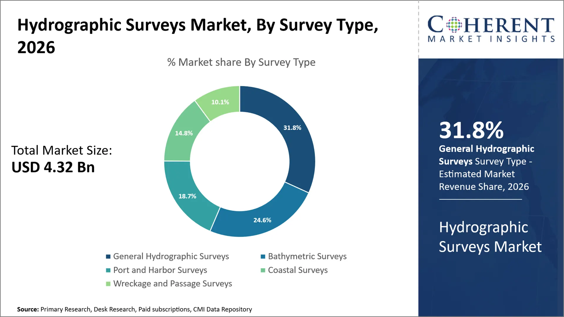
Why Does General Hydrographic Surveys Dominate the Global Hydrographic Surveys Market?
General Hydrographic Surveys are expected to account for 31.8% of the global hydrographic surveys market in 2026, supported by their broad applicability across navigation charting, coastal planning, marine infrastructure assessment, and underwater data collection requirements. Unlike specialized survey categories focused on single applications, general hydrographic surveys provide foundational seabed and water-depth information required by ports, government agencies, engineering firms, and maritime operators. Demand is sustained by the need to maintain updated marine databases as seabed conditions change due to sediment movement, construction activities, and environmental factors. Survey contractors benefit from recurring requirements across commercial and public-sector projects. In February 2025, NOAA announced its 2025 hydrographic survey season, including projects collecting bathymetric data to support nautical charting, research, and marine decision-making.
- Current Industry Events of 2026
- Market Size Estimation
- Regional Breakdown
- Competitive Landscape
- Customer Intelligence
- Segmental Analysis
- Pricing Analysis
- Key Market Drivers, Challenges & Future Trends
- Customized Insights Section
Why Does Multibeam Echo Sounders Represent the Largest Technology Category in the Global Hydrographic Surveys Market?
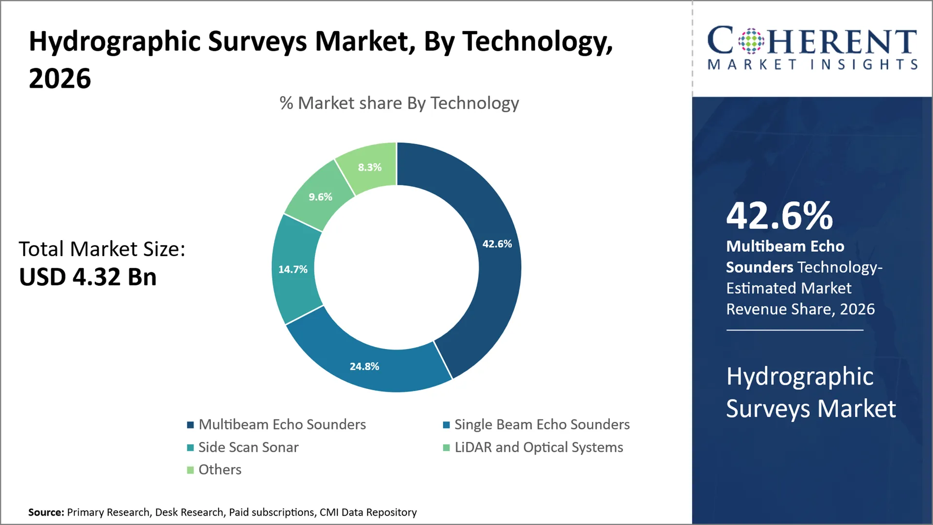
Multibeam Echo Sounders are projected to hold 42.6% of the global hydrographic surveys market in 2026, reflecting their importance in high-resolution seabed mapping where detailed underwater information is required. The technology provides wide-area coverage, improved depth measurement accuracy, and three-dimensional visualization of underwater terrain, making it essential for offshore engineering, port development, defense surveying, and navigation safety applications. Equipment manufacturers benefit from demand for advanced acoustic systems, while survey providers gain operational advantages through faster data acquisition and improved survey quality. Government hydrographic offices and marine authorities increasingly specify multibeam systems for detailed mapping programs requiring internationally accepted accuracy standards. In May 2025, the International Hydrographic Organization published research highlighting the capability of multibeam surveys to achieve high accuracy standards while improving seabed coverage efficiency compared with traditional methods.
Why Does Offshore Oil and Gas Dominate the Application Category of the Global Hydrographic Surveys Market?
Offshore Oil and Gas is expected to represent 32.7% of the global hydrographic surveys market in 2026 due to the sector’s requirement for detailed seabed intelligence throughout exploration, field development, installation, and maintenance activities. Offshore operators rely on hydrographic surveys for pipeline routing, platform positioning, subsea infrastructure planning, and identification of underwater hazards. The segment generates demand for specialized survey vessels, acoustic equipment, positioning systems, and marine data-processing services. Engineering contractors and offshore service providers benefit from long-term project requirements where survey accuracy directly influences operational safety and investment decisions. In November 2025, the Indian Navy commissioned INS Ikshak, a Survey Vessel Large-class vessel equipped with advanced hydrographic and oceanographic systems including high-resolution multibeam echo sounder capabilities, strengthening offshore and maritime survey infrastructure.
Current Events and their Impact
Current Event | Description and Its Impact |
February 2025 – NOAA 2025 Hydrographic Survey Season Initiative |
|
February 2026 – NOAA Office of Coast Survey 2025 Year Review and National Bathymetric Source Expansion |
|
Global Hydrographic Surveys Market Dynamics
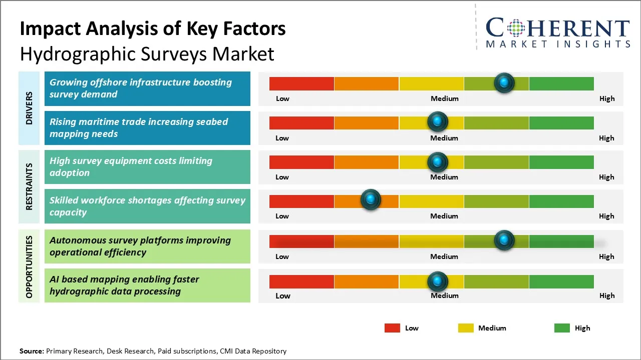
Key Market Drivers
- Growing Offshore Infrastructure Boosting Survey Demand: Growing offshore infrastructure development is strengthening demand for the Hydrographic Surveys Market as offshore energy developers, marine engineering contractors, and infrastructure planners require accurate seabed intelligence before construction activities. Offshore wind farms, subsea transmission networks, offshore platforms, and marine structures depend on hydrographic surveys to evaluate seabed conditions, identify underwater hazards, optimize foundation placement, and reduce project execution risks. This creates opportunities for survey contractors, sonar equipment suppliers, autonomous vessel providers, and marine data-processing companies. In May 2024, the European Marine Board highlighted the increasing importance of marine observation and seabed knowledge for sustainable offshore development and ocean management, reinforcing the need for advanced marine surveying capabilities.
- Rising Maritime Trade Increasing Seabed Mapping Requirements: Expansion of global maritime trade is creating recurring demand for hydrographic surveys as ports, shipping authorities, and marine infrastructure operators require updated seabed information for vessel safety, dredging management, and channel optimization. Unlike one-time mapping activities, commercial waterways require continuous monitoring because sediment movement, port expansion, and increasing vessel sizes can alter navigational conditions. This creates opportunities for hydrographic service providers, digital marine mapping companies, and port technology suppliers offering continuous data solutions. In November 2024, the International Maritime Organization (IMO) emphasized the importance of safe navigation infrastructure and updated hydrographic information as part of efforts to support efficient and secure maritime transportation.
Emerging Market Trends
- Shift Toward Autonomous and Remote Hydrographic Survey Operations: The hydrographic surveys market is gradually moving toward autonomous and remotely operated survey approaches as organizations seek safer operations, lower vessel dependency, and improved access to challenging marine environments. Unmanned surface vehicles and autonomous underwater vehicles are becoming increasingly important for shallow-water mapping, offshore inspections, and repeated monitoring activities. This shift is changing competitive positioning as companies with autonomous navigation, sensor integration, and advanced data-processing capabilities gain advantages over traditional survey providers. Over the forecast period, hybrid survey models combining crewed vessels with autonomous platforms are expected to become more common across commercial and government applications.
- Integration of Advanced Data Analytics with Marine Mapping Workflows: hydrographic survey operations are evolving from data collection-focused services toward integrated marine intelligence solutions. Advanced processing platforms, cloud-based data management, artificial intelligence-assisted interpretation, and improved visualization tools are changing how survey data is converted into actionable information. Customers increasingly expect faster processing, improved accessibility, and integration with geographic information systems for infrastructure planning and environmental management. This trend benefits technology providers and specialized survey firms capable of offering complete data lifecycle solutions rather than standalone measurement services.
Regional Insights
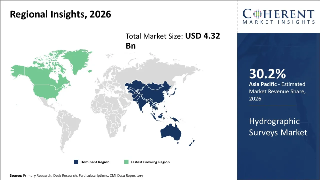
Why Does Asia Pacific Dominate the Global Hydrographic Surveys Market?
Asia Pacific is expected to account for 30.2% of the global hydrographic surveys market in 2026, supported by its extensive coastline, high-density maritime trade routes, large port ecosystem, offshore energy investments, and government focus on marine resource development. The region’s demand is shaped by countries such as China, India, Japan, South Korea, and Southeast Asian economies, where hydrographic surveys are increasingly required for port expansion, offshore wind development, submarine cable installation, coastal zone management, and marine spatial planning. Strong shipbuilding capabilities and expanding blue economy initiatives further strengthen the need for accurate seabed intelligence. In January 2025, the Indian Ministry of Earth Sciences announced continued progress under the Deep Ocean Mission, including activities focused on ocean exploration and marine resource assessment, supporting long-term demand for advanced underwater mapping and survey capabilities.
Why Is North America Emerging as the Fastest-Growing Region in the Global Hydrographic Surveys Market?
North America is projected to achieve the fastest growth in the global hydrographic surveys market, accounting for 29.8% share in 2026, as investments accelerate in offshore wind infrastructure, coastal resilience, defense modernization, and advanced marine data platforms. The region benefits from a mature maritime ecosystem comprising engineering firms, survey contractors, defense agencies, and technology providers developing autonomous and digitally connected survey solutions. Demand is shifting toward higher-value services involving real-time marine intelligence, remote operations, and integrated geospatial datasets rather than conventional depth measurement alone. In October 2024, the U.S. Bureau of Ocean Energy Management (BOEM) released updated offshore wind planning and environmental assessment initiatives, increasing the requirement for detailed seabed characterization and marine spatial information to support offshore project development.
Global Hydrographic Surveys Market Outlook for Key Countries
Why Is the U.S. a Key Market for the Global Hydrographic Surveys Market?
The United States represents a strategically important market for hydrographic surveys due to its extensive coastline, large commercial shipping network, offshore energy activities, defense requirements, and continuous demand for updated nautical charts. The country has one of the world’s most advanced hydrographic infrastructure ecosystems, supported by government agencies, private survey contractors, marine technology companies, and research institutions. U.S. demand is concentrated around port development, coastal management, offshore wind projects, pipeline assessments, and maritime security applications. The country also has strong adoption of autonomous survey technologies that improve operational efficiency and reduce dependency on traditional vessel-based surveys. In January 2025, NOAA’s Office of Coast Survey outlined its continued focus on modernizing hydrographic data collection and improving marine navigation products through advanced surveying approaches.
Why Is India Important in the Global Hydrographic Surveys Market?
India is becoming an important global hydrographic survey market due to its extensive coastline, growing port infrastructure, offshore energy activities, and increasing focus on maritime development. The country’s expanding shipping sector, coastal economic zones, submarine cable projects, and marine resource exploration activities are generating demand for seabed mapping and underwater surveying services. Government initiatives supporting port modernization and ocean exploration are strengthening requirements for advanced hydrographic capabilities. India’s hydrographic ecosystem includes naval surveying capabilities, research organizations, and commercial marine service providers supporting domestic and international projects. In February 2025, India’s Ministry of Earth Sciences highlighted continued activities under ocean exploration programs involving marine mapping and seabed data collection, supporting broader demand for hydrographic technologies.
Why Does China Support Growth in the Global Hydrographic Surveys Market?
China plays a significant role in the global hydrographic surveys market due to its extensive coastline, major global ports, offshore infrastructure development, and strong marine technology ecosystem. The country’s large shipping industry and maritime infrastructure investments require continuous seabed mapping, navigation support, dredging surveys, and underwater engineering assessments. China’s focus on smart ports, offshore renewable energy, and marine resource development is increasing demand for advanced survey technologies including multibeam systems and autonomous platforms. Domestic equipment manufacturers and research institutions are also strengthening local capabilities in marine observation and geospatial data processing. In June 2025, China’s Ministry of Natural Resources reported continued marine surveying and mapping activities supporting coastal management and ocean resource planning.
Why Is Germany a Strategic Country in the Global Hydrographic Surveys Market?
Germany holds strategic importance in the global hydrographic surveys market due to its advanced maritime engineering capabilities, strong offshore wind sector, technologically developed ports, and emphasis on precision marine data management. The country’s North Sea and Baltic Sea activities require detailed seabed information for offshore infrastructure installation, environmental monitoring, navigation safety, and marine spatial planning. Germany’s engineering expertise and strong industrial ecosystem support adoption of advanced sonar systems, geospatial technologies, and integrated marine surveying solutions. The country also benefits from European maritime regulations requiring accurate marine information for sustainable ocean use. In January 2025, Germany’s Federal Maritime and Hydrographic Agency (BSH) continued marine surveying activities supporting navigation, offshore energy planning, and marine environmental management.
Why Is Brazil an Important Growth Market for the Global Hydrographic Surveys Market?
Brazil represents an emerging growth market for global hydrographic surveys market due to its extensive Atlantic coastline, offshore oil and gas activities, port expansion requirements, and marine infrastructure development. The country’s offshore energy sector creates continuous demand for seabed assessment, pipeline route surveys, and underwater inspection services. Brazilian ports, coastal engineering projects, and maritime authorities also require updated hydrographic information to improve navigation efficiency and support infrastructure planning. The country’s marine resource potential and offshore development activities create opportunities for survey companies, technology providers, and specialized service contractors. In May 2025, Brazil’s Directorate of Hydrography and Navigation (DHN) continued maritime surveying and nautical charting activities supporting safe navigation and marine operations.
Technology Deployment and Infrastructure Landscape in the Global Hydrographic Surveys Market
Technology | Current Adoption Status | Commercial Applications | Strategic Impact |
Multibeam Echo Sounders | Widely adopted as the primary high-resolution seabed mapping technology for commercial, government, and defense hydrographic operations. | Used for detailed bathymetric surveys, offshore infrastructure planning, port dredging assessments, underwater obstacle detection, and navigation chart production. | Enables higher accuracy seabed visualization and supports premium survey services where data quality and precision directly influence project decisions. |
Single Beam Echo Sounders | Established technology primarily used for cost-efficient depth measurement and routine hydrographic applications. | Applied in shallow-water surveys, preliminary site assessments, inland water mapping, and smaller-scale marine projects. | Remains important for price-sensitive customers by providing reliable depth data with lower operational complexity compared with advanced acoustic systems. |
Side Scan Sonar Systems | Increasingly integrated with hydrographic workflows requiring seabed imagery and underwater object identification. | Used for wreck detection, pipeline and cable route inspection, defense applications, environmental surveys, and seabed classification. | Expands the value proposition of survey providers by combining depth measurement with visual interpretation of underwater features. |
Uncrewed Surface Vehicles (USVs) | Rapidly expanding adoption as survey organizations seek operational efficiency, reduced vessel dependency, and safer access to difficult areas. | Applied in shallow-water mapping, coastal surveys, emergency response, and autonomous bathymetric data collection. | Creates opportunities for lower-cost survey models and enables service providers to increase coverage without proportionally increasing vessel and crew requirements. NOAA has expanded the use of uncrewed surface vehicles to improve hydrographic survey efficiency and extend mapping capabilities. |
Autonomous Underwater Vehicles (AUVs) | Growing adoption for deepwater and specialized marine exploration activities requiring independent underwater operations. | Used for deep-sea mapping, offshore inspection, defense surveys, scientific exploration, and complex seabed investigations. | Supports new survey capabilities in environments where traditional vessels face operational limitations by enabling high-resolution underwater data collection. |
LiDAR and Optical Mapping Systems | Selective adoption in shallow-water and coastal applications where optical visibility conditions are suitable. | Used for shoreline mapping, coastal engineering, flood assessment, habitat studies, and topographic-bathymetric surveys. | Provides complementary mapping capabilities by integrating above-water and shallow-water datasets, improving multi-dimensional coastal intelligence. |
How Are Autonomous Survey Platforms and Integrated Marine Data Solutions Creating New Growth Opportunities in the Global Hydrographic Surveys Market?
Autonomous survey platforms combined with integrated marine data solutions represent a significant commercial opportunity for the Hydrographic Surveys Market by enabling faster, safer, and more cost-efficient underwater data acquisition. Unmanned surface vehicles, autonomous underwater vehicles, and advanced processing platforms allow survey providers to expand operations into remote, hazardous, or frequently monitored marine environments. Offshore energy developers, port authorities, defense organizations, and coastal management agencies represent key customer groups adopting these capabilities. Companies can capture this opportunity by combining hardware, software, analytics, and subscription-based data services rather than relying only on traditional survey contracts. The opportunity favors technology specialists, integrated solution providers, and established survey companies capable of developing autonomous capabilities and digital workflows. Investment priorities will include sensor integration, artificial intelligence-based interpretation, remote operations, cybersecurity, and interoperability with geographic information systems to deliver comprehensive marine intelligence solutions.
Market Players, Key Development, and Competitive Landscape
Key Developments
- In June 2025, Fugro continued expanding its remote and autonomous survey approach through digital marine data solutions and remote operations capabilities. This is important for the global hydrographic surveys market because autonomous survey models support scalable offshore mapping activities while reducing dependence on traditional vessel-based operations.
- In March 2025, Teledyne Marine continued advancing integrated marine measurement solutions combining sonar, navigation, and underwater sensing technologies. This is important for the global hydrographic surveys market because integrated marine systems enable survey contractors and government users to improve operational efficiency and collect more comprehensive underwater datasets.
- In January 2025, Kongsberg Discovery expanded its marine technology portfolio through continued development of advanced hydroacoustic and autonomous solutions supporting ocean mapping and underwater operations. This is important for the global hydrographic surveys market because improved sensor integration strengthens high-resolution seabed data collection capabilities and supports next-generation survey workflows.
Competitive Landscape
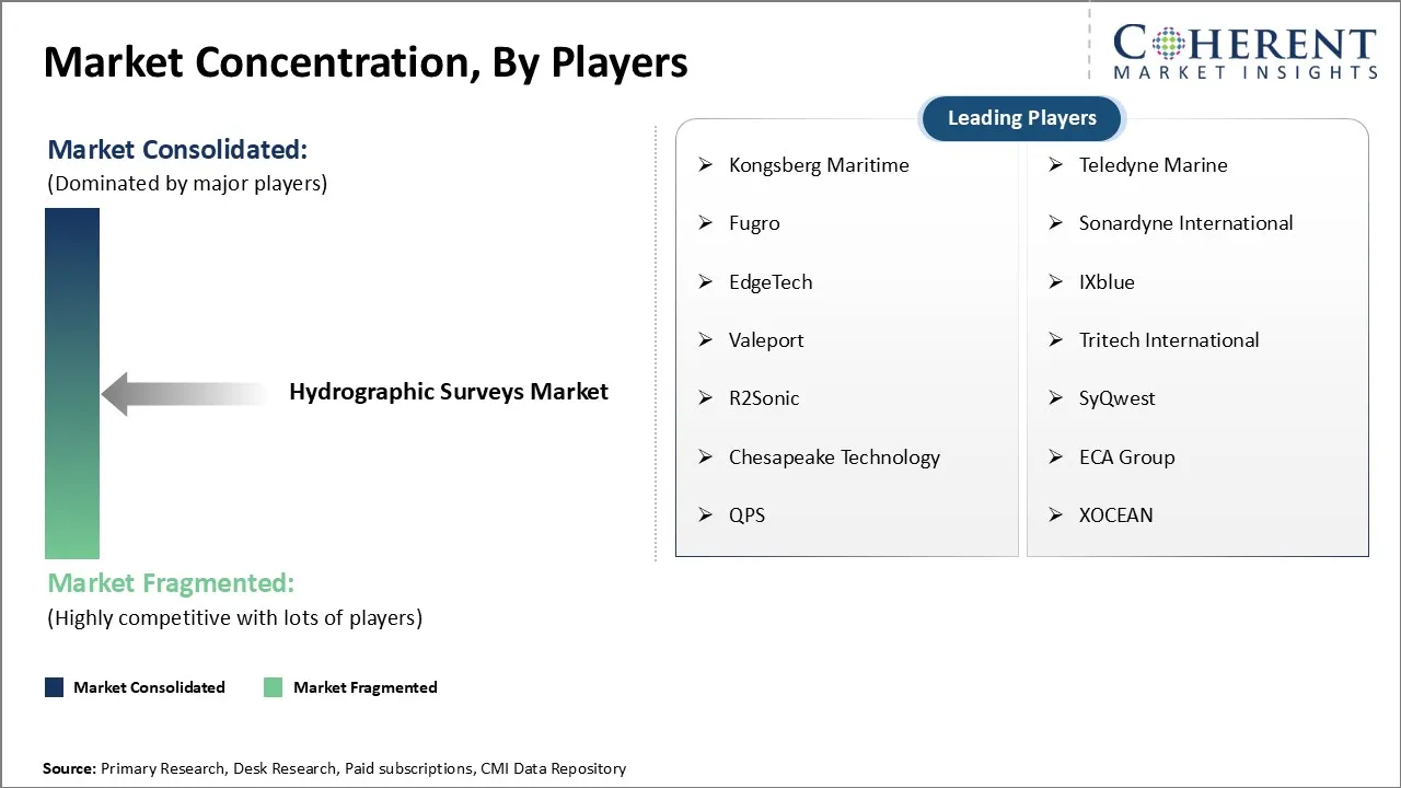
The global hydrographic surveys market is moderately consolidated, with competition distributed among specialized hydrographic survey companies, marine technology manufacturers, defense contractors, and geospatial solution providers. Market positioning depends on survey accuracy, sensor capabilities, vessel and autonomous platform availability, data-processing expertise, regulatory compliance, and customer relationships. Large players compete through integrated service offerings, while regional specialists maintain advantages through local marine knowledge and project execution capabilities.
Key Focus Areas Include
- Advanced sensing technology capabilities including multibeam echo sounders, sonar systems, LiDAR, and integrated marine sensors.
- Survey accuracy and data quality as customers increasingly require reliable seabed information for infrastructure planning and marine operations.
- Autonomous platform adoption through unmanned surface vehicles and underwater systems to improve operational efficiency.
- Technical expertise and specialized marine capabilities for offshore, coastal, defense, and engineering applications.
- Data processing and digital workflow integration to convert survey outputs into actionable marine intelligence.
- Regulatory compliance and certification capability to meet international hydrographic standards and navigation requirements.
- Global project execution capability through vessel fleets, regional presence, and partnerships.
- Customer relationships and long-term contracts with governments, offshore operators, ports, and infrastructure developers.
Market Report Scope
Hydrographic Surveys Market Report Coverage | |||
Report Coverage | Details | ||
Base Year | 2025 | Market Size in 2026: | USD 4.32 Bn |
Historical Data For: | 2020 To 2024 | Forecast Period: | 2026 To 2033 |
Forecast Period 2026 To 2033 CAGR: | 6.6% | 2033 Value Projection: | USD 6.76 Bn |
Geographies covered: |
| ||
Segments covered: |
| ||
Companies covered: | Kongsberg Maritime, Teledyne Marine, Fugro, Sonardyne International, EdgeTech, IXblue, Valeport, Tritech International, R2Sonic, SyQwest, Chesapeake Technology, ECA Group, QPS, XOCEAN | ||
Growth Drivers: |
| ||
Restraints & Challenges: |
| ||
Analyst Opinion (Expert Opinion)
- The global hydrographic surveys market is likely to transition from a vessel-centric service model toward integrated marine intelligence platforms. Future competitive differentiation will depend less on individual survey equipment ownership and more on the ability to combine autonomous operations, advanced analytics, and continuous data services. Companies that develop complete decision-support ecosystems may achieve stronger customer retention than providers offering only survey execution.
- The increasing adoption of autonomous marine systems could significantly reshape traditional survey economics. Organizations relying heavily on conventional vessel operations may face pressure as customers evaluate lower-cost and more flexible alternatives. The strongest market positions will likely emerge among companies capable of combining autonomous hardware, software platforms, and specialized marine expertise into scalable solutions.
- Market participants should prioritize investment in autonomous technologies, digital data platforms, and specialized application knowledge. Companies should focus on high-value sectors such as offshore infrastructure, marine engineering, and defense while managing risks related to technology integration costs, cybersecurity requirements, and skilled workforce availability. Strategic partnerships between technology developers and survey service providers will become increasingly important for market expansion.
Speak to the analyst
Want personalized insights?
Take the findings above to one of our principal consultants, or have the report rebuilt around the segments, geographies and competitors you actually track.
Market Segmentation
- Survey Type Insights (Revenue, USD Bn, 2021 - 2033)
- General Hydrographic Surveys
- Bathymetric Surveys
- Port and Harbor Surveys
- Coastal Surveys
- Wreckage and Passage Surveys
- Technology Insights (Revenue, USD Bn, 2021 - 2033)
- Multibeam Echo Sounders
- Single Beam Echo Sounders
- Side Scan Sonar
- LiDAR and Optical Systems
- Others
- Application Insights (Revenue, USD Bn, 2021 - 2033)
- Offshore Oil and Gas
- Port and Harbor Management
- Coastal Engineering
- Cable and Pipeline Route Survey
- Defense and Security
- Platform Insights (Revenue, USD Bn, 2021 - 2033)
- Surface Vessels
- Unmanned Surface and Underwater Vehicles
- Manned Survey Vessels
- Aircraft and UAVs
- End User Insights (Revenue, USD Bn, 2021 - 2033)
- Commercial
- Government and Defense
- Research Institutions
- Regional Insights (Revenue, USD Bn, 2021 - 2033)
- North America
- U.S.
- Canada
- Latin America
- Brazil
- Argentina
- Mexico
- Rest of Latin America
- Europe
- Germany
- U.K.
- Spain
- France
- Italy
- Russia
- Rest of Europe
- Asia Pacific
- China
- India
- Japan
- Australia
- South Korea
- ASEAN
- Rest of Asia Pacific
- Middle East
- GCC Countries
- Israel
- Rest of Middle East
- Africa
- South Africa
- North Africa
- Central Africa
- North America
- Key Players Insights
- Kongsberg Maritime
- Teledyne Marine
- Fugro
- Sonardyne International
- EdgeTech
- IXblue
- Valeport
- Tritech International
- R2Sonic
- SyQwest
- Chesapeake Technology
- ECA Group
- QPS
- XOCEAN
Sources
Primary Research Interviews
- Hydrographic survey service providers, marine survey contractors, offshore engineering companies, port authorities, defense organizations, and marine technology suppliers
- Hydrographic specialists, survey engineers, ocean mapping experts, geospatial professionals, offshore project managers, and maritime infrastructure consultants
Stakeholders
- Hydrographic survey companies, marine geospatial solution providers, sonar equipment manufacturers, autonomous survey platform developers, and navigation technology suppliers
- Port operators, offshore energy developers, subsea engineering companies, dredging contractors, shipping companies, and government hydrographic agencies
- Research institutions, oceanographic organizations, coastal management authorities, and marine environmental monitoring bodies
End-use Sectors
- Offshore oil & gas exploration, subsea infrastructure development, and pipeline/cable route planning
- Port and harbor management, dredging operations, and maritime navigation safety
- Coastal engineering, marine construction, and environmental monitoring applications
- Defense, naval operations, ocean research, and underwater resource assessment
Regulatory and Industry Bodies
- International Hydrographic Organization (IHO)
- National hydrographic offices and maritime authorities
- International Maritime Organization (IMO)
- Offshore energy and marine infrastructure regulatory bodies
- Oceanographic and geospatial data management organizations
Databases
- Company annual reports, investor presentations, and corporate filings
- Hydrographic survey project databases and marine infrastructure databases
- Port development, offshore energy, and maritime investment databases
- Government marine mapping datasets and oceanographic databases
- Trade statistics, vessel activity databases, and geospatial information repositories
Magazines and Journals
- Hydrographic surveying and marine technology publications
- Ocean engineering and geospatial science journals
- Offshore energy and subsea infrastructure publications
- Maritime transportation and port development journals
- Remote sensing, sonar technology, and autonomous systems publications
Associations
- International Hydrographic Organization (IHO)
- International Association of Ports and Harbors (IAPH)
- International Marine Contractors Association (IMCA)
- Offshore industry associations
- Geospatial and ocean science organizations
Public Domain Sources
- Government marine surveying programs and nautical charting initiatives
- Offshore wind, oil & gas, and subsea infrastructure developments
- Autonomous marine technology deployment trends
- Port modernization and maritime trade developments
- Coastal resilience and ocean mapping initiatives
Key Standards and Regulations
- International hydrographic surveying standards (IHO S-44)
- Maritime navigation and charting requirements
- Offshore construction and subsea engineering guidelines
- Marine environmental assessment regulations
- Data quality, geospatial standards, and ocean mapping protocols
Proprietary Elements
- CMI Data Analytics Tool., Proprietary CMI repository containing 10+ years of marine infrastructure, energy, industrial technology, and maritime market intelligence.
Get access to 250+ pages report
Every segment, forecast, competitor profile and data table behind the analysis above — available for instant download.
- ESOMAR Member
- ISO 9001:2015 Certified
- D-U-N-S Registered
- GDPR & CCPA Compliant
Missing comfort of reading report in your local language? Find your preferred language:
Frequently Asked Questions
The CAGR of global hydrographic surveys market is projected to be 6.6% from 2026 to 2033.
The global hydrographic surveys market is estimated to be valued at USD 4.32 billion in 2026 and is expected to reach USD 6.76 billion by 2033.
The global hydrographic surveys market covers applications including offshore infrastructure development, port and harbor management, coastal engineering, underwater route assessment, marine construction, defense operations, and oceanographic research.
Hydrographic surveying commonly uses multibeam echo sounders, single beam echo sounders, side scan sonar, LiDAR systems, autonomous underwater vehicles (AUVs), unmanned surface vehicles (USVs), and advanced marine data-processing platforms.
Key end users include offshore energy companies, port authorities, government hydrographic agencies, defense organizations, marine engineering contractors, research institutions, and environmental monitoring organizations.
Companies typically evaluate survey accuracy, technology capabilities, data-processing efficiency, operational coverage, regulatory compliance, equipment reliability, service expertise, and long-term maintenance support before investing in hydrographic survey solutions.
Growing offshore infrastructure development and increasing maritime trade activity are the key factors supporting the growth of the global hydrographic surveys market.