

Global Location Intelligence Market Size and Forecast – 2026 To 2033
The global location intelligence market is expected to grow from USD 26 Bn in 2026 to USD 60 Bn by 2033, registering a compound annual growth rate (CAGR) of 13% from 2026 to 2033. The global location intelligence market is driven by the growing deployment of AI integrated geospatial intelligence platforms. On April 29, 2026, Google Cloud and CARTO expanded their Agentic GIS ecosystem at Google Cloud Next 2026, with CARTO being named the exclusive Agentic GIS provider in the Gemini Enterprise Agent Marketplace.
Key Takeaways of the Global Location Intelligence Market
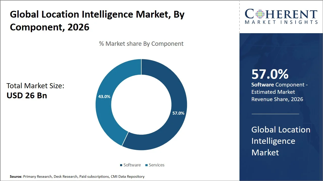
- The software segment is expected to account for 57.0 % of the global location intelligence market share in 2026. Higher investment in satellite imagery and real time spatial data platforms is driving the growth of the segment. On April 15, 2025, EarthDaily Analytics successfully launched the first satellites of its EarthDaily Constellation and expanded the constellation with additional launches through May 2026.
- The cloud segment is estimated to capture 62.0 % of the market share in 2026. Increasing adoption of cloud native location intelligence platforms is majorly driving the growth of the segment. On April 27, 2026, Google Maps Platform expanded its enterprise cloud ecosystem with new geospatial datasets and AI-ready services integrated directly into BigQuery, powered by Google Earth AI foundation models.
- The supply chain and logistics segment is estimated to capture 24.0 % of the market share in 2026. Expansion of logistics fleet optimization and last mile delivery solutions is driving the growth of the segment. On April 21, 2026, Ekart announced the expansion of its partnership with IKEA to strengthen the global home furnishing brand’s last-mile logistics in Chennai, India.
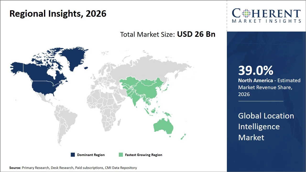
- North America is expected to dominate the location intelligence market in 2026 with a market share of 39.0 %. Rising demand from autonomous vehicles and connected mobility in North America is driving the growth of the regional market. On May 1, 2025, Aurora Innovation, Inc. successfully launched its commercial self-driving trucking service in Texas, U.S. Following the closure of its safety case, Aurora began regular driverless customer deliveries between Dallas and Houston, U.S.
- Asia Pacific is expected to account for 29.0 % of the market share in 2026 and is projected to record the fastest growth over the forecast period. Growth in precision agriculture and environmental monitoring in Asia Pacific is driving the growth of the regional market. On August 26, 2025, Pixxel successfully launched three new Firefly satellites aboard the SpaceX NAOS Falcon 9 mission, completing the first phase of its commercial constellation and moving closer to building a health monitor for the planet.
- Rapid Integration of Generative AI and Geospatial Analytics: Generative AI and large language models are being embedded into location intelligence solutions, automating spatial analysis, revealing geographic patterns, generating predictive insights, and facilitating natural language interaction with GIS datasets to greatly accelerate decision-making in logistics, retail, utilities, and public sector operations.
- Growing Adoption of Digital Twin Platforms with Real-Time Location Data: Companies are using IoT sensors, satellite imagery, LiDAR, and GIS to build dynamic digital twins of cities, industrial sites, transportation systems, and utility infrastructure, enabling real-time spatial intelligence for ongoing monitoring, predictive maintenance, asset optimization, and infrastructure planning.
Segmental Insights
Why Does Software Dominate the Global Location Intelligence Market?
The software segment is expected to account for 57.0% of the global location intelligence market share in 2026. The software segment is dominating the worldwide location intelligence market because it is the central platform for integrating, analyzing, displaying and managing spatial data from different sources in real time. Today’s location intelligence software combines GIS, artificial intelligence, cloud computing, satellite imaging and business analytics in one environment, so enterprises may gain useful information without having to deploy numerous separate solutions. Enterprises looking for scalable, data-driven decision support in logistics, retail, utilities, government and transportation sectors have centralized this capabilities, making software the key investment emphasis. On July 14, 2025, Esri, the global leader in geographic information system (GIS) technology, announced that it is integrating Microsoft Azure OpenAI Service into ArcGIS. This powerful collaboration equips users with all new AI assistants to simplify work with geospatial data, maps, and analytics.
- Current Industry Events of 2026
- Market Size Estimation
- Regional Breakdown
- Competitive Landscape
- Customer Intelligence
- Segmental Analysis
- Pricing Analysis
- Key Market Drivers, Challenges & Future Trends
- Customized Insights Section
Why is Cloud the Most Preferred Deployment Type?
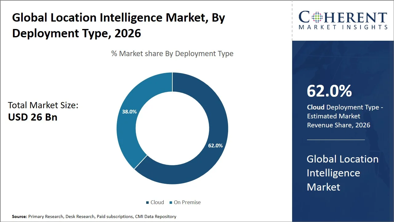
The cloud segment is expected to account for 62.0% of the global location intelligence market share in 2026. Cloud is the most desired deployment type among all types of deployment types as it enables enterprises to process and analyze huge volumes of real-time geospatial data with almost unlimited scalability and reduces the infrastructure management requirements dramatically. Cloud-based location intelligence platforms allow easy integration of satellite imagery, IoT devices, GPS data and enterprise applications, helping users get location insights from anywhere with faster updates, lower deployment costs and better collaboration across geographically dispersed teams. On March 12, 2026, Google made a big upgrade to the Google Maps Platform, incorporating powerful Gemini-powered building agents and an Model Context Protocol (MCP) server. These enhancements enabled developers to design highly interactive map-based projects and generate map aesthetics from basic, natural-language text cues.
Supply Chain and Logistics Segment Dominates the Global Location Intelligence Market
The supply chain and logistics segment is expected to account for 24.0% of the global location intelligence market share in 2026. Supply chain and logistics is the largest application category due to the essential function of location intelligence in the optimization of transportation routes, fleet operations, warehouse networks, and last-mile deliveries through real-time geospatial visibility.
Organizations are using spatial analytics in order to track vehicle fleets, anticipate delivery delays, decrease fuel consumption, optimize asset utilization and respond rapidly to disruptions caused by traffic, weather or infrastructure constraints. Today’s supply chain and logistics operations require location intelligence as a must-have technology that helps organizations enhance operational efficiency and reduce transportation costs. On June 25, 2026, Delhivery announced that it will deploy about 1500 Bajaj electric cargo trucks across India, boosting AI-enabled fleet optimization, real-time route planning and last-mile logistics efficiency, while lowering operating costs and emissions.
Currents Events and their Impact
Current Events | Description and its Impact |
European Union AI Act |
|
United States Executive Order on Strengthening and Promoting Innovation in the Nation's Cybersecurity |
|
Global Location Intelligence Market Dynamics
Market Drivers
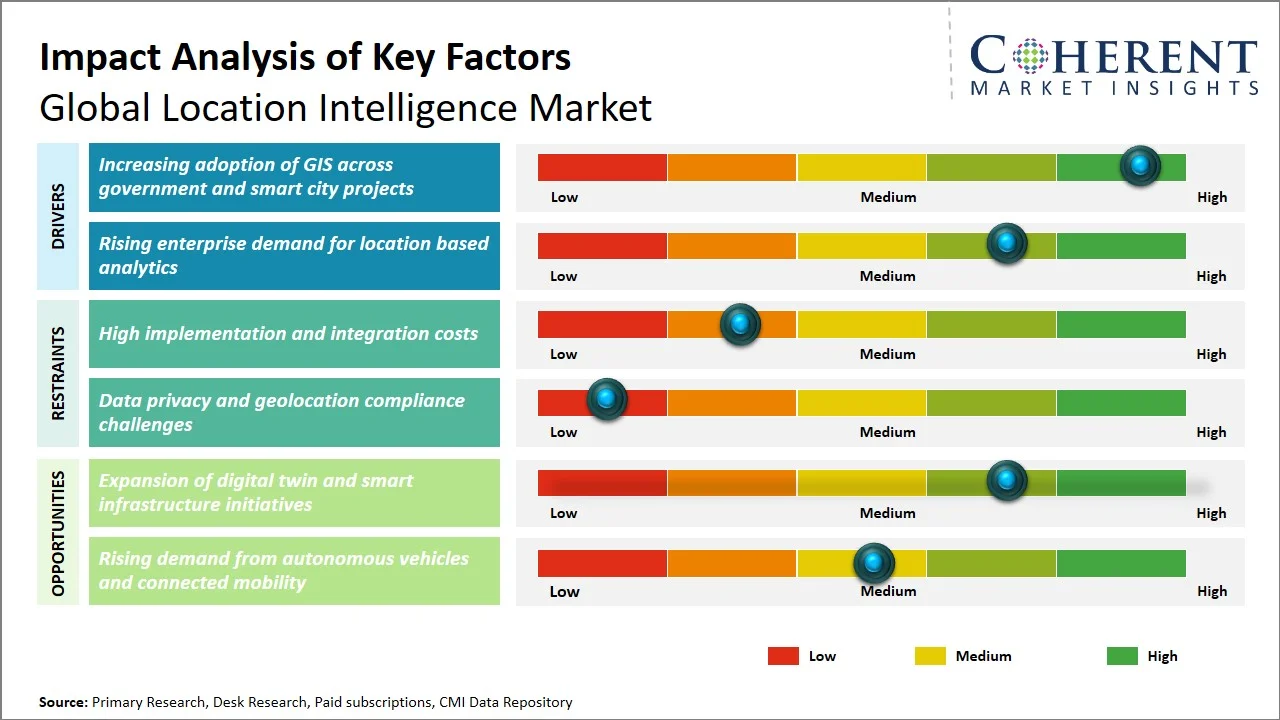
- Increasing adoption of GIS across government and smart city projects: Governments around the world are increasing the use of geographic information systems for urban planning, transport management, land administration, emergency response, utility monitoring and public infrastructure development. As smart city initiatives are more and more adopting GIS platforms, they are integrating spatial data from IoT sensors, connected infrastructure, satellite imagery and digital twins to help authorities optimize resource allocation, monitor city assets in real time and support data-driven policy decisions. The increased investment in the public sector is leading to a strong need for sophisticated location intelligence solutions. On December 16, 2025, Esri India became the Strategic Sponsor for GeoSmart India 2026 further strengthening its association with government entities on the national geospatial modernization, digital governance, land administration and smart city programs through the ArcGIS platform.
- Rising enterprise demand for location based analytics: Enterprises across retail, logistics, financial services, telecommunications, manufacturing and healthcare are turning to location based analytics in order to increase operational efficiency and boost strategic decision-making processes. By merging consumer, operational, and geographic data, firms can optimize supply chains, find high-value market possibilities, increase asset utilization, customize customer engagement, and strengthen risk management. The increased emphasis on data-driven business strategies is driving enterprise investment in scalable location intelligence solutions. On July 8, 2025, Intersec announced the launch of Intersec AI, embedding domain-specific AI agents into its location intelligence platform to help telecommunications operators and enterprise customers automate mobility analytics, customer behavior monitoring, and real-time geographic decision-making.
Emerging Trends
- Expansion of Indoor Location Intelligence Solutions: Growing adoption of Bluetooth Low Energy, Ultra-Wideband, Wi-Fi positioning and computer vision technologies is fueling the need for indoor mapping and navigation in hospitals, airports, manufacturing plants, warehouses and commercial buildings where GPS service is unavailable.
- Increasing Commercial Use of High-Resolution Earth Observation Data: Companies are utilizing high-frequency satellite imagery, drone mapping, and aerial geospatial data for applications such as environmental monitoring, precision agriculture, insurance risk assessment, mining operations, renewable energy site selection, and climate resilience planning, opening up new avenues for advanced location intelligence platforms.
Regional Insights
Why is North America a Strong Market for Location Intelligence?
North America is expected to account for a market share of 39.0% in 2026. North America continues to be the dominant regional market for location intelligence, with broad acceptance of enterprise GIS, cloud-native geospatial analytics, and AI-powered mapping platforms. The U.S. and Canada continue to invest extensively in smart transportation, energy upgrading, and public safety systems, with agencies such as the U.S. Geological Survey, NASA, and National Geospatial-Intelligence Agency supporting broad geospatial data ecosystems. Major technology companies including Esri, Google, Microsoft, Precisely, and Trimble are doubling down on cloud-based spatial analytics, while logistics providers and retailers are moving toward real-time location intelligence for fleet management, asset tracking, and omnichannel operations.
Why Does the Asia Pacific Location Intelligence Market Exhibit High Growth?
Asia Pacific is projected to account for 29.0% of the global location intelligence market and is expected to register the fastest growth. The Asia Pacific region’s growth is driven by large scale smart city projects, the growth of digital infrastructure and increased satellite observation capabilities. In China, Japan, South Korea, India and Singapore, GIS usage is rising for urban planning, transportation management, disaster resilience and environmental monitoring. Governments are pairing digital twin technology with geospatial platforms for infrastructure planning and telecommunications companies, e-commerce companies and logistics providers are using AI-enabled location analysis to optimize delivery networks, mobility services and regional supply chains.
Global Location Intelligence Market Outlook for Key Countries
Why is the U.S. Emerging as a Major Hub in the Location Intelligence Market?
The U.S. is the largest market because of the developed geospatial ecosystem and high use in the defense, transportation, utilities, retail, insurance, and healthcare sectors. Cloud-based application development is extensively supported by platforms such as Google Maps Platform, Microsoft Azure Maps, and Amazon Location Service. Esri continues to dominate enterprise GIS deployments. There is increasing demand for advanced spatial analytics, spurred by federal efforts to modernize infrastructure, monitor wildfires, enhance climate resilience, and improve emergency management, as well as the needs of autonomous vehicle developers and logistics companies that rely on high-definition mapping and real-time location intelligence to make operational decisions.
Is China the Next Growth Engine for the Location Intelligence Market?
China has built one of the most advanced location intelligence ecosystems in the world, with its massive BeiDou Navigation Satellite System, national digital infrastructure, and large-scale smart city programs. Integrated GIS, mapping and location analytics solutions are supplied by companies such as Baidu, Alibaba Cloud, Tencent and SuperMap Software to support transportation, public administration and industrial applications. The rapid proliferation of autonomous driving technologies, intelligent logistics networks, and urban digital twin projects in the public and commercial sectors is fueling the demand for high-precision geospatial data and AI-driven spatial analytics.
Germany Location Intelligence Market Analysis and Trends
Germany is a key European market, fueled by its robust industrial digitization plan and extensive use of geospatial technology in manufacturing, automotive engineering, energy, and transportation. Organizations are rapidly incorporating location intelligence into Industry 4.0 platforms to optimize plant logistics, infrastructure maintenance, and supply chain visibility. Enterprise need for precise spatial analytics continues to be driven by sophisticated mapping and geospatial solutions, railway modernization, renewable energy planning and intelligent transportation initiatives, with help from organizations such as HERE Technologies and Hexagon.
U.K. Location Intelligence Market Analysis and Trends
The U.K. has a sophisticated location intelligence business, underpinned by strong public sector geospatial programs and use by financial services. Ordnance Survey provides detailed national mapping data to help applications in infrastructure development, utilities, telecommunications, insurance and property analytics. Organizations are increasingly using artificial intelligence together with geographical data to improve flood risk modelling, optimize transport networks and guide urban planning, while cloud-based GIS systems continue to gain traction with government agencies and commercial organizations.
Japan Location Intelligence Market Analysis and Trends
Japan has a very developed location intelligence market, fueled by precision mapping, disaster preparedness, intelligent transportation systems and smart infrastructure management. Organizations heavily rely on high-resolution geospatial data, satellite images, and digital twin technologies to monitor key infrastructure, manage earthquake and flood risks, and enhance urban mobility. Major technology companies, automobile manufacturers, and electronics firms continue to invest in high-definition mapping for autonomous driving, while national smart city projects are spreading the use of AI-enabled geospatial analytics across municipalities and industrial enterprises.
Global Location Intelligence Market - Connected Vehicle Location Intelligence Integration Trends
Region | Connected Vehicle Integration Level | Primary Location Intelligence Use Case | Key Supporting Technologies |
North America | 88% | Autonomous driving and fleet management | HD Maps, AI, 5G, GNSS, Edge Computing |
Europe | 82% | Intelligent transportation systems | C-V2X, Digital Twins, GNSS, AI |
Asia Pacific | 79% | Connected mobility and smart cities | BeiDou, 5G, AI, HD Mapping |
Latin America | 57% | Fleet tracking and route optimization | GPS, Cloud GIS, IoT |
Middle East & Africa | 49% | Commercial fleet monitoring | GNSS, Telematics, Cloud Analytics |
How is the Expansion of Digital Twin and Smart Infrastructure Initiatives Creating New Growth Opportunities in the Location Intelligence Market?
Increasing digital twin and smart infrastructure programs are promoting profitable growth in the location intelligence market, owing to the increased demand for real-time geospatial data integration, continuous asset monitoring, and predictive spatial analytics. Location intelligence platforms enable the integration of geographic information systems, IoT sensor data, satellite imagery, LiDAR and building information modeling into dynamic virtual environments that are digital twins of cities, transportation networks, industrial facilities, utilities and public infrastructure. This empowers infrastructure owners and government agencies to optimize maintenance schedules, improve traffic management, promote energy efficiency, track environmental conditions and support disaster preparedness with exact location-based analytics.
On January 5, 2026, Bentley Systems, Incorporated announced the acquisition of Talon Aerolytics and the technology and technical expertise of Pointivo. These acquisitions significantly strengthen Bentley’s Asset Analytics portfolio, which applies digital twins and AI to help owner-operators improve asset performance and resilience across infrastructure sectors.
Market Players, Key Development, and Competitive Landscape
Key Developments
- On March 27, 2026, Successive Digital announced a strategic partnership with ESRI India. Through this collaboration, Successive Digital will act as a Solutions Partner to help organizations harness advanced geospatial technologies and location intelligence to drive smarter decision-making and operational efficiency.
- On October 22, 2025, Esri introduced ArcGIS 2025 with expanded AI-powered spatial analysis and enhanced 3D digital twin capabilities. The 2025 update includes new capabilities in Map Viewer, AI assistants for Arcade, new labeling options, and other improvements and new capabilities.
Competitive Landscape
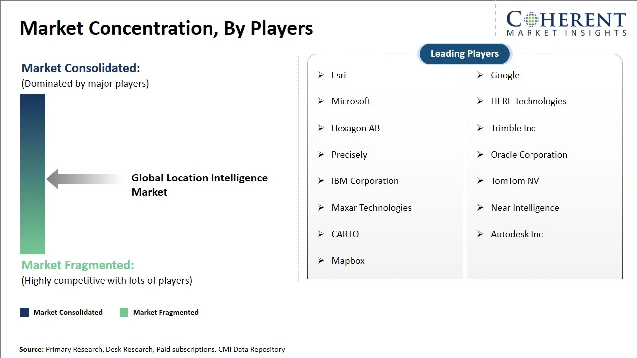
The location intelligence market is not about traditional mapping skills, but about constant innovation in cloud-native GIS platforms, AI-powered spatial analytics, and high-resolution geospatial data integration. To accommodate the rising complexity of the enterprise’s needs, vendors are expanding their support for real-time satellite imagery, drone-derived information, digital twin environments and edge-based location processing. Product development is centered on integrated spatial data platforms that combine mapping, predictive analytics, IoT connectivity and business intelligence into a single operational environment with interoperability to enterprise applications and open geospatial standards emerging as a key differentiator.
Market Report Scope
Location Intelligence Market Report Coverage
| Report Coverage | Details | ||
|---|---|---|---|
| Base Year: | 2025 | Market Size in 2026: | USD 26 Bn |
| Historical Data for: | 2020 To 2024 | Forecast Period: | 2026 To 2033 |
| Forecast Period 2026 to 2033 CAGR: | 13% | 2033 Value Projection: | USD 60 Bn |
| Geographies covered: |
| ||
| Segments covered: |
| ||
| Companies covered: | Esri, Google, Microsoft, HERE Technologies, Hexagon AB, Trimble Inc, Precisely, Oracle Corporation, IBM Corporation, TomTom NV, Maxar Technologies, Near Intelligence, CARTO, Autodesk Inc, and Mapbox | ||
| Growth Drivers: |
| ||
| Restraints & Challenges: |
| ||
Analyst Opinion (Expert Opinion)
- The next phase of the location intelligence industry will be autonomous spatial decision-making, where geospatial systems will go beyond visualization to automatically recommend and execute operational actions based on real geographic conditions. Enterprise deployments are expected to increasingly combine foundation AI models, real-time Earth observation data, edge computing, and centimeter-level positioning technologies into unified spatial intelligence ecosystems for continuous monitoring of infrastructure, mobility networks, industrial assets, and environmental conditions.
- As 3D geospatial modeling, digital twins and high frequency satellite data become standard enterprise resources, location intelligence is forecasted to evolve into a core operational layer supporting predictive planning, automated asset orchestration and mission critical decision support across both public and private sectors.
- Location intelligence is set to be a key component of future market growth as it converges with autonomous mobility, robotics, climate intelligence and industrial digital twins. With organizations demanding for faster decision support with more context, high precision positioning, real-time 3D geospatial visualization and geospatial foundation models are expected to be standard offerings across enterprise platforms. Growth of commercial satellite constellations, edge AI processing and continuing infrastructure monitoring are likely to make location intelligence a continuously functioning operational intelligence layer for governments and corporations.
Speak to the analyst
Want personalized insights?
Take the findings above to one of our principal consultants, or have the report rebuilt around the segments, geographies and competitors you actually track.
Market Segmentation
- Component Insights (Revenue, USD Billion, 2021 - 2033)
- Software
- Services
- Deployment Type Insights (Revenue, USD Billion, 2021 - 2033)
- Cloud
- On-Premise
- Application Insights (Revenue, USD Billion, 2021 - 2033)
- Supply Chain and Logistics
- Risk Management
- Customer Analytics
- Asset Management
- Workforce Management
- Remote Monitoring
- Sales and Marketing Optimization
- Others
- End User Insights (Revenue, USD Billion, 2021 - 2033)
- Retail
- Transportation and Logistics
- Government and Defense
- BFSI
- Healthcare
- Telecommunications
- Energy and Utilities
- Manufacturing
- Agriculture
- Others
- Regional Insights (Revenue, USD Billion, 2021 - 2033)
- North America
- U.S.
- Canada
- Latin America
- Brazil
- Argentina
- Mexico
- Rest of Latin America
- Europe
- Germany
- U.K.
- Spain
- France
- Italy
- Russia
- Rest of Europe
- Asia Pacific
- China
- India
- Japan
- Australia
- South Korea
- ASEAN
- Rest of Asia Pacific
- Middle East
- GCC Countries
- Israel
- Rest of Middle East
- Africa
- South Africa
- North Africa
- Central Africa
- North America
- Key Players Insights
- Esri
- Microsoft
- HERE Technologies
- Hexagon AB
- Trimble Inc
- Precisely
- Oracle Corporation
- IBM Corporation
- TomTom NV
- Maxar Technologies
- Near Intelligence
- CARTO
- Autodesk Inc
- Mapbox
Sources
Primary Research Interviews
- GIS Solution Providers
- Location-Based Services (LBS) Technology Vendors
- Retail & E-commerce Industry Executives
- Transportation & Logistics Decision Makers
Magazines
- GeoSpatial World Magazine
- Directions Magazine (GIS & Location Intelligence)
- GPS World Magazine
- Geospatial Solutions Magazine
Journals
- International Journal of Geographical Information Science (IJGIS)
- Journal of Location Based Services (Taylor & Francis)
- Computers, Environment and Urban Systems (Elsevier)
Associations
- Urban and Regional Information Systems Association (URISA)
- Open Geospatial Consortium (OGC)
- American Association of Geographers (AAG)
- Geospatial Information & Technology Association (GITA)
Public Domain Sources
- U.S. Geological Survey (USGS) – Geospatial Data
- European Space Agency (ESA) – Copernicus Open Access Hub
- United Nations Statistics Division – Geospatial Data Portal
- National Oceanic and Atmospheric Administration (NOAA) – Open Data
Proprietary Elements
- CMI Data Analytics Tool
- Proprietary CMI Existing Repository of Information for Last 10 Years
Get access to 250+ pages report
Every segment, forecast, competitor profile and data table behind the analysis above — available for instant download.
- ESOMAR Member
- ISO 9001:2015 Certified
- D-U-N-S Registered
- GDPR & CCPA Compliant
Missing comfort of reading report in your local language? Find your preferred language:
Transform your Strategy with Exclusive Trending Reports
Frequently Asked Questions
The global location intelligence market is expected to stand at USD 26 Bn in 2026 and is expected to reach USD 60 Bn by 2033.
The CAGR of the global Location Intelligence market is projected to be 13% from 2026 to 2033.
Increasing adoption of GIS across government and smart city projects and rising enterprise demand for location based analytics are the major factors driving the growth of the global location intelligence market.
High implementation and integration costs and data privacy and geolocation compliance challenges are the major factors hampering the growth of the global location intelligence market.
In terms of component, the software segment is estimated to dominate the market revenue share in 2026.
Satellites provide high-resolution imagery and positioning data for mapping, monitoring, and spatial analysis.
It enhances route planning, shipment visibility, warehouse optimization, and real-time logistics management.